Investments without interest rates, good for the whole world, seas connected, easy with actual technology, projects leading to a peace spirit for everyones, improving life conditions of millions of people.
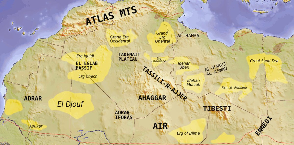


Even the CIA has explored the consequences of flooding the Qattara Depression in Libya. One advantage that intrigues modern engineers is the possibility of generating massive quantities of hydroelectric power. It would require a canal (or a pair of tunnels ,according to one proposal) only 40 miles long to connect the depression with the sea. The drop of 440 feet would be more than sufficient for the generation of power. Concerns over things such as the impact on indigenous peoples and wildlife are among the many major obstacles to these plans.

By Eric Gaba (Sting – fr:Sting) and NordNordWest – Topographic background map: Own workSource of data: SRTM30 PlusAll other data taken from File:Egypt_location_map.svg created by NordNordWest under GFDL/CC-BY-SA 3.0, CC BY-SA 3.0, https://commons.wikimedia.org/w/index.php?curid=9676527
exemple: http://ebooks.cambridge.org/chapter.jsf?bid=CBO9780511535697&cid=CBO9780511535697A260
This is the maximum height that a siphon will work. Substituting values will give approximately 10 metres for water and, by definition of standard pressure, 0.76 metres (760 mm or 30 in) for mercury. The ratio of heights (about 13.6) equals the ratio of densities of water and mercury (at a given temperature). Note that as long as this condition is satisfied (pressure greater than zero), the flow at the output of the siphon is still only governed by the height difference between the source surface and the outlet. Volume of fluid in the apparatus is not relevant as long as the pressure head remains above zero in every section. Because pressure drops when velocity is increased, a static siphon (or manometer) can have a slightly higher height than a flowing siphon.
Solar pond[edit]
Boron nitride nanotubes[edit]
Sahara Sea – Wikipedia
A relief map of Egypt, with the Qattara Depression shown in blue. The Sahara Sea was the name of a hypothetical macro-engineering project which proposed flooding endorheic basins in the SaharaDesert with …
Qattara Depression Project – Wikipedia
The Qattara Depression Project, or shortly the Qattara Project, is a concept for a large civil engineering project in Egypt, rivaling the Aswan High Dam, intended to develop the Qattara Depression by floodingit. …. See also[edit]. Qattara Depression · Sahara Sea · Salton Sea …
The Great Sahara Sea That Almost Was – io9
20 juil. 2013 – Even the CIA has explored the consequences of flooding the Qattara Depression in Libya. One advantage that intrigues modern engineers is …
Flooding the Sahara | Alternate History Discussion
The Sahara desert by itself is pretty worthless by itself, flooding it would … Try looking for the QattaraDepression – a significant engineering …
Qattara Depression Project: Time to Revisit? – The Energy Collective
10 août 2016 – If the depression were flooded to sea level, the lake formed would cover …. SaharaDesert and its extreme arid climate, the Qattara Depression …
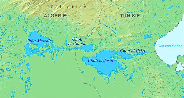
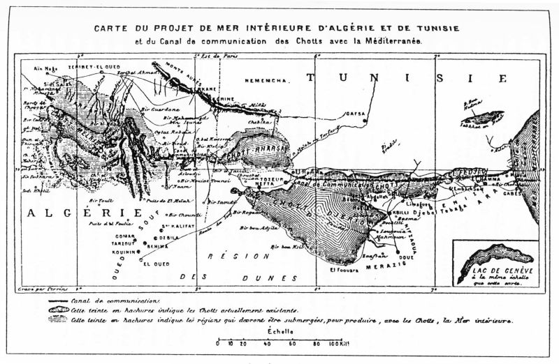
Flooding of the Sahara depressions (Appendix E) – Inter-Basin Water …
INTRODUCTION. The idea of flooding the Sahara depressions goes back to the second half of the nineteenth century. The aim was to divert waters of the …
Why The Sahara Sea Doesn’t Exist…Yet – Condé Nast Traveler
7 nov. 2016 – The bottom of the Qattara Depression is 436 feet below sea level, … but just then, a giant earthquake strikes, flooding the desert anyway.
Hiding Rising Seas in Sunken Deserts | The Mountain Mystery
17 août 2015 – Nevertheless, the Dead Sea Depression, flooded with sea water, … also slated for drowning, but the enormous Sahara tracts are not deep.
Would it be possible or even beneficial to flood the Sahara? : askscience
I was reading about some theories in th 1800s and 1900s to flood a part of the Sahara which, if i understood correctly, would turn Northern… … Found this about flooding the Qattara Depression near Cairo. And then there’s this …
Terraform Mars? Whay not terraform the sahara desert? [Archive …
This flooding would create an inland sea, and in the desrt heat, …. Quattara Depression were flooded(with salt water from the Mediterranean), …
Commentaires récents